Overview
A large server migration is occurring October 20th, 2026 from 4:30pm-6:30pm. Potential outages will be experienced during this window. Some users will need to take action to regain connection.
Most data access is done through the GIS API (aka. the rest API / "services"). Some select users have direct SQL access to the database, the "SDE". Anyone with an SDE connection must follow the steps outlined in the section "SDE Connections".
API Impacts
There are no impacts to API syntax, authorization, or structure. This maintenance window will only impact connectivity, which will be restored at the end of the maintenance window.
User Example
- Person: "I use the GIS API for the building entrances service."
- Person: "The application I have uses the service URL 'https://gissvc.osu.edu/arcgis/rest/services/Data/ReferenceData_RO/MapServer/10'"
- This person has no action to take. But will potentially have connectivity issues during the outage window.
SDE Impacts
Anyone using ArcGIS Pro to connect to our database will be required to correct there connection file. The SDE connections are native to ArcGIS Pro and direct connection to the SQL database. Users impacted by this change are being reached out to directly. If you suspect this change impacts you or are unsure, contact us at gismaps@osu.edu.
User Example
- Person: "I use ArcGIS Pro and I edit data within the FITS GIS database."
- This person must take action outlined in this article (SDE connection repair) for all ArcGIS Pro projects.
- Do not complete this change until after the maintenance window on 10/20.
Instructions on SDE repair
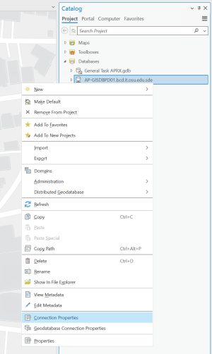
- Open your ArcGIS Pro project and expand the Catalog pane options for databases and locate your SDE connection.
- Alter the "Connection Properties"
- Your connection properties should be identical to this:
- Database Platform: SQL Server
- Instance: ap-gis-dbprd.it.ohio-state.edu (this is the only change, it is no longer "AP-GISDBPD01.bcd.it.osu.edu")
- Authentication Type: Operating System Authentication
Database: OSU
- Your connection properties should be identical to this:
- Additional clean up will need done and will be difficult to spot. The rest of these steps are suggestions on the most effective way to clean up your maps.
- Rename the SQL connection file. It is likely still named some older name, right click the database again and rename. Recommended: ap-gis-dbprd Connection
- You will need to reconnect each layer to the SDE
- The fastest way is to click a broken layer with the "red exclamation point" and re-map the data to the connection and layer name. This will sometimes apply edits to multiple layers after you do one.
- Another quick way: remove all the layers from your map and re-add them from the SDE.
- Alternatively follow these steps to re-map access.
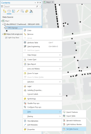
- In the Contents pane toggle to the "List by Data Source" view. The goal is to make everything connected to a database say "ap-gis-pwds01" in the source
Pick a layer in the group of old sources. The image is an example of a signage layer with an old connection string. Then right click, go to data, and data sources.
In the pop-up window that appears ensure you go to the connection in the file explorer and point to the layer.
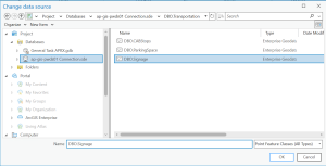
Once you have properly remapped, you will notice the layer is in a new group in the Content pane with a group name containing the new connection path.

- After this make sure you save your project.
User Example
- Person: "I use ArcGIS Pro and I edit data within the FITS GIS database."
- This person must take action outlined in this article (SDE connection repair) for all ArcGIS Pro projects.
- Do not complete this change until after the maintenance window on 10/20.
Instructions on ArcGIS Pro Updates
- As part of this update, you may decide to update ArcGIS Pro to the latest release.
- You will need to install a new .net version and SQL driver. Both can be provided if you contact clark.3020@osu.edu.
- If you have access to the network share, get the most recently added files from both sub folders here: ...\GIS\Administration\Software\Installs\ArcGIS Pro
- The network file share will need remapped for those that use it.
- This new directory will be shared if you contact clark.3020@osu.edu